Captain’s Blog: 8/19/2024
The following information was first published in the book “the lost language of Braveheart & Robert De Bruce King of Scots,” by Katie May Tucker and Dr. Wayne R. Tucker 1st edition copyright 2022, ISBN: 978-1-6781-8173-4. Additional information since the publication date had been added and follows international copyright laws.
excerpt from the lost language of Braveheart & King of Scots
Section 4: Key to the Cipher the Catalan Atlas
4.1 ANALYSIS
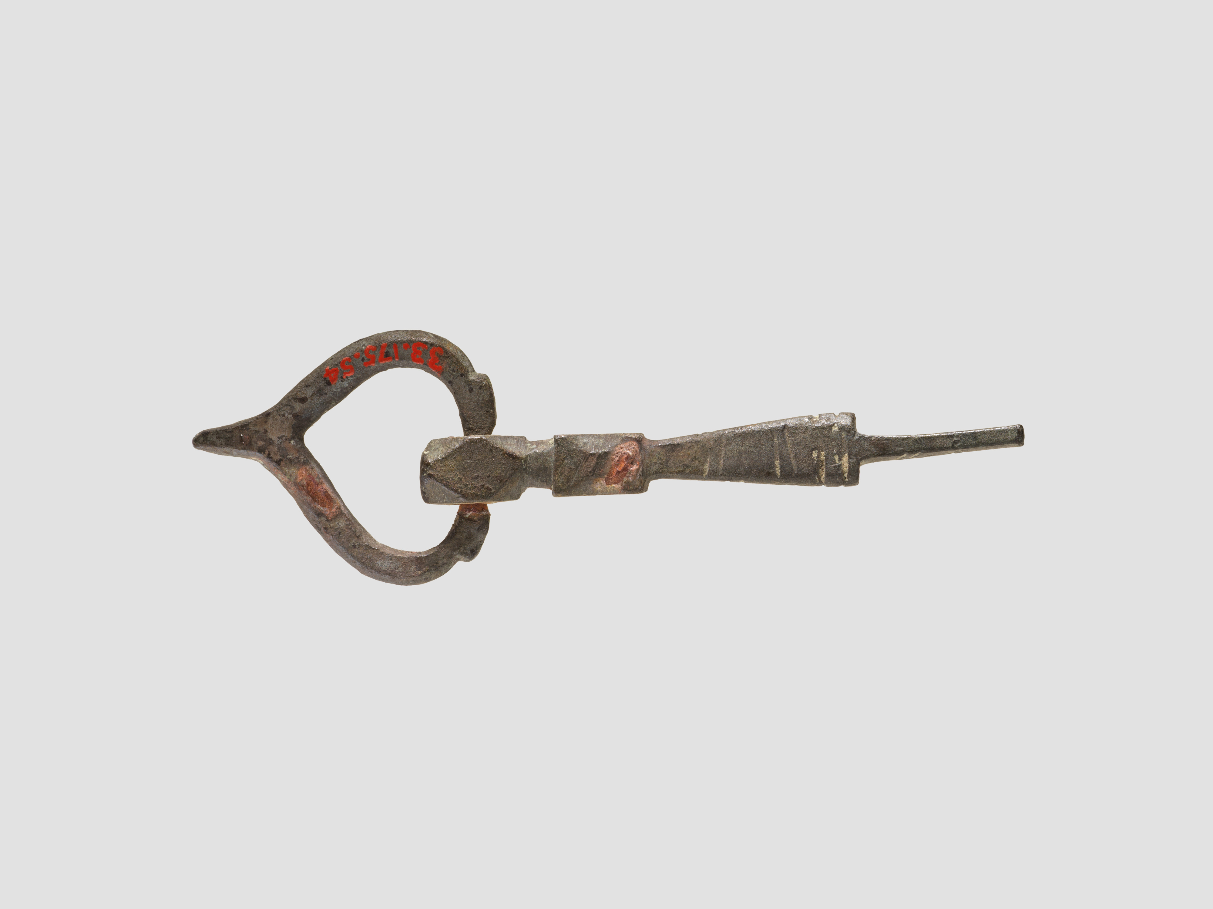
The key to the cipher of the VM was located within the Catalan Atlas. Through an analysis of the atlas’s attributes and cartographic loci, the cipher’s point of origin—or zero-set point—was identified. This discovery occurred after the completion of the Phase III analysis and enabled the necessary modifications to the alphabetic system and base language. The observed language frequency was then compared with the Catalan Atlas “key” and found to correspond. The linguist(s) who created the VM appear to have employed the full semantic range of words, including meanings derived from their etymological origins, thereby producing broader and more comprehensive definitions. For example, the word key is attested in Old English and Scots with meanings such as “key,” “solution,” and “experiment.” Although its ultimate origin remains uncertain, it has been associated with the Proto-Germanic sense of “stake,” “post,” or “pole.” Medieval keys were often elongated implements that could be described as crooked, bent, or twisted. As noted previously, the zero-longitude point of the Catalan Atlas is derived from calculations based on the ellipsoidal shape of the Earth; this calculation is associated with the rhumb line. In this interpretation, a rhumb line of the Catalan Atlas functions as the key to the solution, as its curved, bending, and twisting trajectories traverse the latitude lines toward true north.
The key to the VM is based on the following definition of the word “key” from Old English “key, solution, experiment.”
Noun
•The key in the Catalan Atlas was designed to open Europe to the “otherwordly place.”
•The key in the Catalan Atlas was designed to fit between two other objects (Prime Meridian points of a map rhumb line) to maintain their relative orientation.
•The key is a crucial step or requirement to the voyage in the VM and all voyages to this day.
•(figuratively) The general pitch or tone of the VM is from the region that the Catalan Atlas key is located; also, the context of the Catalan Atlas and VM are the same – International Maritime Trade.
•(botany) An indehiscent, one-seeded fruit furnished with a wing, such as the fruit of the ash and maple; a samara. Used figuratively the Oak/Elm Trees from Oak Island is the starting point (surveyors bearing tree) and monetary foundation to the VM.
•(cryptography) A piece of information (e.g. a passphrase) used to encode or decode a message or messages. Without the Catalan Atlas you can not decode the VM.
•(masonry) A keystone. The VM law is the foundation in which Modern Society was built.
Adjective
•Indispensable, supremely important.
•Important, salient.
•Worthy of note; pertinent or relevant.
•Prominent; conspicuous.
•(heraldry, usually of a quadruped) Depicted in a leaping posture.
•(often military) Projecting outwards, pointing outwards.
•(obsolete) Moving by leaps or springs; jumping.
•(obsolete) Shooting or springing out; projecting.
•(geometry) Denoting any angle less than two right angles.
Verb (The Voynich Manuscript was made to:)
•To fit (adjust) trade routes
•To fit (in agreement) with international merchants in alliance between them.
•to carry a mark (marquee) to indicate with a symbol they are a member in the alliance
•To link (as one might do with a key or legend).
•To attune to create peace and harmony to the world.
•To fasten or secure firmly with members in the group.
(side note: and lets not forget it also references the Chinese word chi pronounced “key” meaning energy force.)
4.2 RESULTS
4.2.1 CATALAN ATLAS OVERVIEW
The Catalan Atlas is, like the Voynich Manuscript (VM), an object of considerable historical and interpretive uncertainty, and its precise authorship remains unresolved. It is generally believed to have been produced in 1375 and to have entered the Royal Library of France by 1380, during the reign of King Charles V. Its map legends, written in Catalan, appear to encode information through the combined use of riddles, mythology, and legendary material. The Catalan Atlas includes a representation of the world as it was known to a broader medieval audience; an early compass rose; and material related to cosmography, astronomy, calculation, and astrology. Its mathematical systems were innovative for their period and include various symbols associated with navigational bearings, several of which have also been identified in the Voynich Manuscript.
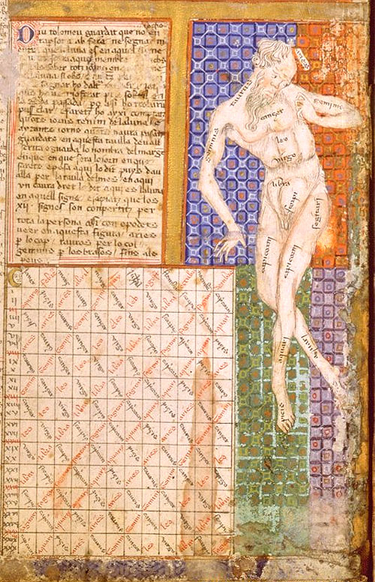
Comparison of the Catalan Atlas text with the figure previously identified as the “zodiac man” suggests an association with bloodletting practices; however, in relation to the VM, these elements may function as riddles corresponding to information embedded in the manuscript’s text. The Catalan Atlas states: “Ptolemy says: Beware of touching your body with iron or letting blood so long as the moon stands in the sign that is given on the relevant part of the body. If you wish to know in which sign the moon stands when you need a surgical intervention, blood-letting, or anything of the kind refer to what we have indicated in the previous ‘wheel.’ … And know that the 12 signs are scattered over the whole of the body as you can see on the picture. Aries on the head. Taurus on the neck. Gemini on the arms, and so on down to the feet.”
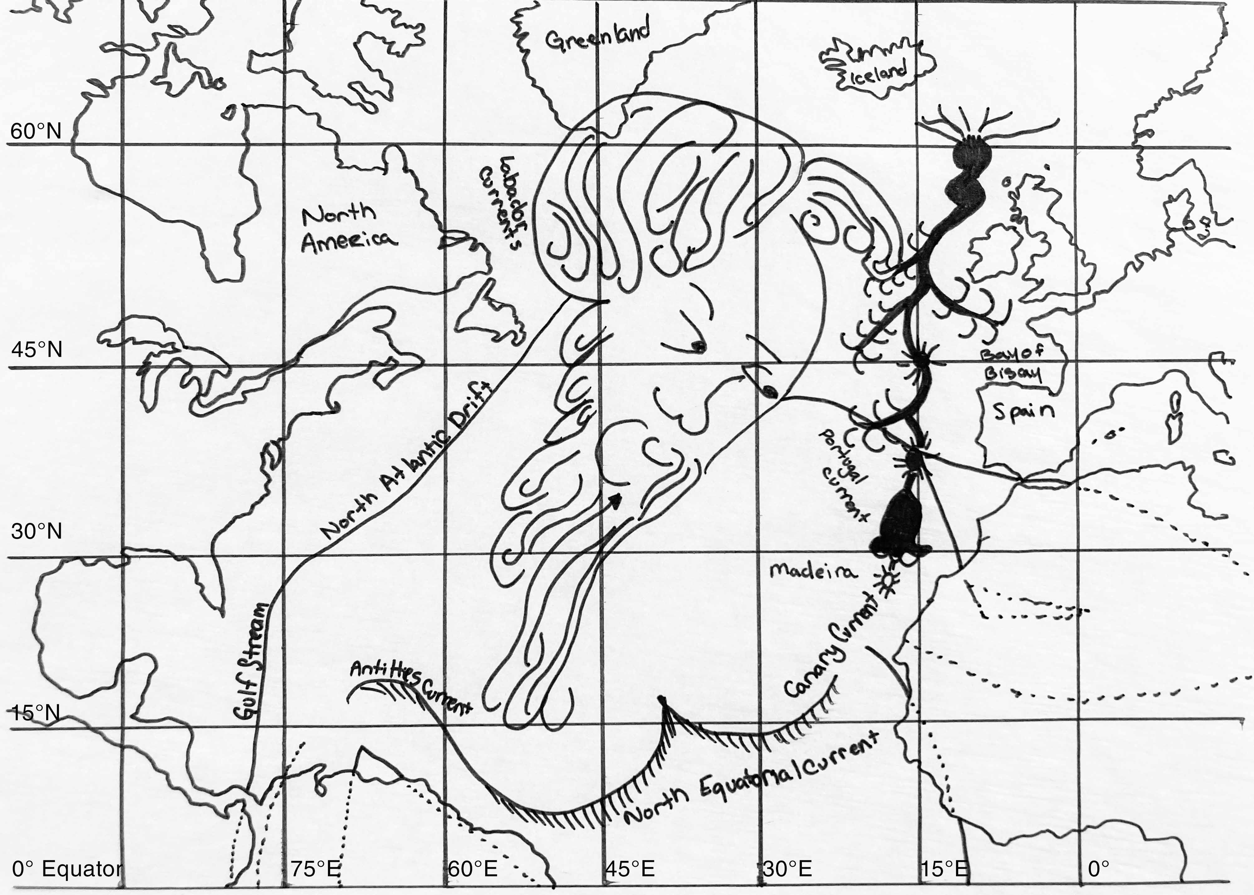
Further comparison with other fourteenth-century depictions of the Zodiac Man indicates that the figure in the Catalan Atlas does not share the same defining attributes. We therefore identify this figure as Poseidon, the Greek god of the sea. In this interpretation, each zodiac sign placed on the body corresponds to an ocean gyre. The Poseidon figure in the Catalan Atlas is then understood as a referential device within the VM text, establishing a map grid for the Atlantic Ocean.
4.2.2 THE ROSE COMPASS
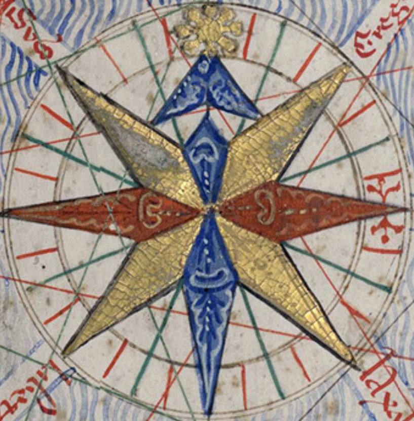
The earliest known appearance of a compass rose is found in the Catalan Atlas. A compass rose, also known as a “rose of the winds,” is a visual representation of the cardinal directions: north, south, east, and west. In “Where Do Cardinal Directions Come From?,” published in Anthropological Linguistics, Vol. 25, C. H. Brown argues that cardinal-direction terms commonly derive from locally specific geographic features, such as “towards the highlands” or “towards Scotland,” or from celestial bodies, the sun, winds, or temperature.
Within Scottish cultural traditions, flowers may symbolize particular individuals, clans, or regions. References to specific flowers could therefore have indicated both cardinal direction and the group of people associated with that direction. The full extent of floral symbolism in Scottish culture remains uncertain. During the course of this study, we contacted the Kirkcudbright Bay Historical Society, which confirmed the importance of identifying people, clans, and regions through floral motifs. At the time of this research’s publication, however, the society was still conducting its own investigation into the cultural significance of flowers in Scotland; once published, that work may further inform the present study.
The Voynich Manuscript (VM) appears to employ Scottish floral symbolism as a means of indicating cardinal direction while concealing the hypothesis that the flowers function as maps. Within these floral forms are navigational markings that appear to draw on Old English property-law conventions, Old Norse runic symbolism, and Scottish systems of directional reference. The flowers in the VM may therefore represent more than sequential navigational instructions: the leaves may indicate wind speed, ship masts, ocean currents, tides, time, or related maritime information. Each map in the VM is specific to the geographic location it represents; these locations will be discussed in detail by folio number in this blog.
4.2.3 CATALAN ATLAS COMPARATIVE ANALYSIS TO VOYNICH MANUSCRIPT
The following are examples of how artwork in the VM and the Catalan Atlas Compare.
•Folio 3r: use of the Catalan Atlas loci points and map. (see maps in previous blog post)
•Folio 3v: use of the Catalan Atlas loci points and map.
•Folio 4r: use of the Catalan Atlas loci points and map.
•Folio 4v: Use of “Zodiac Man” Grid aka Poseidon
•Folio 5r: Madeira Island was supposedly not discovered until 1419, but is accurately mapped in the Catalan Atlas 1375 and in MS 408 by 1430. Recently archeological evidence shows Vikings inhabited these islands by 700AD.
•Folio 5v: use of the Catalan Atlas loci points and map.
•Folio 6r: use of the Catalan Atlas loci points and map.
•Folio 6v: use of the Catalan Atlas loci points and map.
•Folio 7r: Loci Points and secant arc from Canary Island “Teroerife”
•Folio 7v: use of the Catalan Atlas loci points and map.
•Folio 8r: use of the Catalan Atlas loci points and map.
•Folio 8v: use of the Catalan Atlas loci points and map.
•Folio 11r: The secant arc and wind measurements are drawn into the sails of the ship.
•Folio 18r: Use of the “Zodiac” Poseidon Man Grid
•Folio 24v: Poseidon Grid shift in Atlantic to Prime Meridian.(*)
•Folio 25v: Rose Atlas from the Catalan Atlas
•Folio 29v: Flowers are Polish Church’s in the Catalan Atlas, (pg. 49) depicting Kiev Ukraine longitude.
•Folio 30v: Parson Bird. To confirm channel location, the authors put in an Easter Egg of the Parsons Bird and reference the borders of the known world. Near the 36°E mark of the borders of the Catalan Atlas a parson bird was drawn. The Parsons Bird lives in the Auckland Islands of New Zealand approx. 30° S.
•Folio 34r: Catalan Atlas “Zodiac” Poseidon Man Meridian Grid shift and crosses the equator twice
•Folio 37r: Two naked men diving for pearls in the Indian Ocean is the same position as folio 37r. The Catalan Atlas states “In the Indian Ocean where they are fishermen and very rich islands. The fisherman that descend into the sea say their incantations before diving into the sea and this way they dispel the fish. In the event that they do not say them, the fish devour them, and this has been demonstrated.” Folio 37r has a precision cut in the upper right corner, which is exactly the Catalan Atlas cartographers green line in the Indian Ocean. The folio corrective ligature in the center of the right side is also in the Catalan Atlas cartographers green line in the Gulf of Oman. The folio ligature is in the same position as the gold flag with a red square (the flag for Ilkhanate) is located in the Catalan Atlas.
•Folio 37v: The lower left Folio 37v ligature is in the position of the Catalan Atlas Flag of Diogil. It is said that the Monkey God Hanuman’s birthplace was Hampi, India. The folio ligature, the flag of Diogil and Hampi India are all the same coordinates.
•Folio 40r: At this location the Catalan Atlas has an inscription reading “Island of naked people, where men and women wear a leaf in front and one in back.” However, such an island does not exist. The Catalan Atlas just like the Voynich has riddles. Given our modern world knowledge one could guess the riddle means this is an exposed area and to protect your ship from the back and front.
•Folio 40v: The Riddle of Melusine and geolocation of Melusine in the Catalan Atlas.
•Folio 41r: There is an inscription in this region saying “In the sea of the Indies there are seven thousand five hundred and forty-eight islands whose wonders of gold, silver, spices and precious stones we cannot discuss here.
•Folio 41v: Catalan Atlas used two naked men as the South China Sea Monsoon currents with an inscription saying “These people are savages; they live on raw fish, they drink sea water and go around naked.” Which the author is using a play on words to reference mesoscale eddies in South China Sea Current and not actual people.
•Folio 42r: The crowns of the foreign dignitaries begging for spices in China, which bear the same latitude, have the same flower leaves as depicted in the MS 408 leaves.
•Folio 42v: Text references the Great Wall of China and the edge of the known world drawn in the Catalan Atlas.
•Folio 43r: in between the pillars are fine “wheel grid” nod marks. In the translation, the authors point out a “sister” – which in the Catalan Atlas Catholic Sisters are drawn in this region. When lining both of these up together the nods are off the shore of China just east of Shanghai.
•Folio 75r-77v: use of loci points connected to the Catalan Atlas.
4.2.4 LOCI POINTS
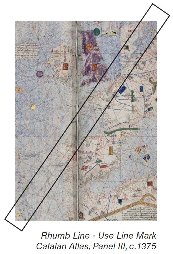
The Voynich Manuscript (VM) appears to employ the rhumb line as a key, as illustrated below. Rhumb lines did not become widely documented in public cartographic discourse until 1537. In fifteenth-century cartography, a rhumb line represented a path of constant bearing toward true north, forming an arc that intersects all meridian longitudes. A closer examination suggests that the Catalan Atlas of 1375 developed the rhumb line through an orb projection system, as described in the translation of VM Folio 1r. This cartographic projection appears to be based on a point-perspective model derived from the mariner’s forty-eight-point compass in three dimensions. The rhumb line was not part of the atlas’s original cartographic design; however, it appears to have been used frequently enough that the surveyor’s iron ruler left a watermark in the upper corner extending toward the central loci point of Panel III.
The rhumb-line system, together with the Catalan Atlas’s forty-eight-point compass projection, appears to have been used to divide time-zones according to the zenith angle of the sun. Although standardized time-zones were not publicly adopted until 1878, the VM appears to reference changes in time and movement into different zones according to solar orientation. This system resembles modern time-zone divisions; however, contemporary time zones are generally organized by political or national boundaries rather than by longitude.
4.2.5 MERIDIAN LINE – ZERO LONGITUDE
The identification of the key in relation to the prime meridians was developed through a process of reverse engineering. The analysis first established an understanding of the Catalan Atlas, then of the cipher, and subsequently of the linguistic system through which the manuscript appears to operate. These elements converged during the examination of their interrelationship, leading to the identification of the key and its connection to both the Voynich Manuscript (VM) and the Catalan Atlas. In constructing this key, the Catalan Atlas appears to have used four prime meridians to generate the rhumb-line arc; however, when represented on a two-dimensional surface, the perspective of the meridian line necessarily appears linear.
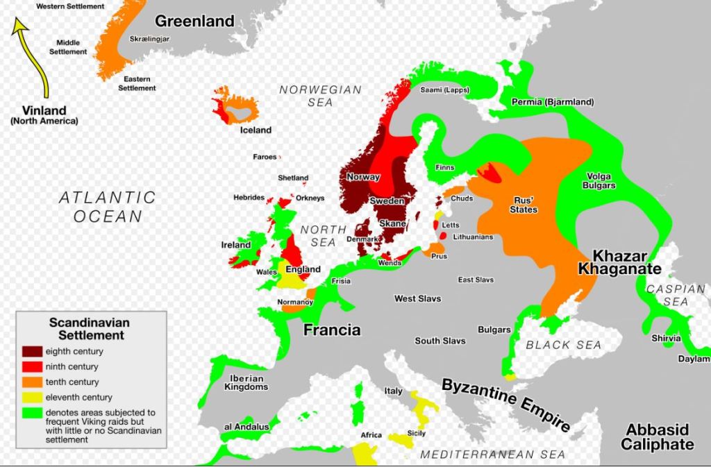
The designation of a prime meridian, or zero longitude, has been contested since antiquity, and several locations have historically functioned as zero-longitude reference points, including Paris, France; Greenwich, England; the Isle of Rhodes; and El Hierro, also known historically as the Isle de Meridiano in the Canary Islands. In the present interpretation, each of these locations is necessary for deciphering the key to the VM. As represented in the Catalan Atlas, the cipher key is centered on Greenwich, England, and corresponds to Galwegian Middle English, a linguistic variety associated with the region indicated by the yellow triangular diagram on the following page. These meridian points, including the Azores, were settled by Vikings as early as the eighth century CE.
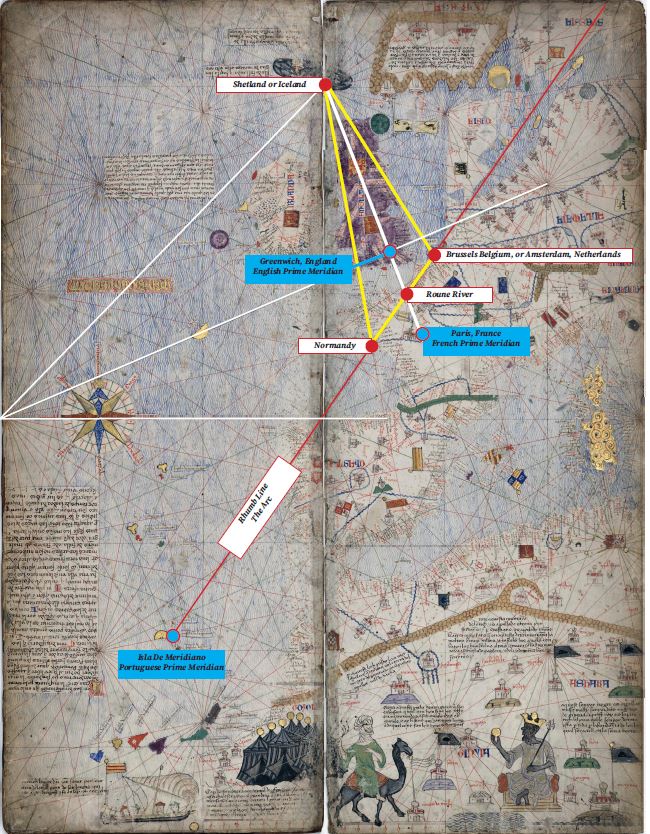
When the proposed key to the Voynich Manuscript is compared with known Viking and Scandinavian settlement patterns, a notable correspondence emerges. The linguistic system discussed elsewhere in this study is identified as Galwegian Middle English, a dialect associated with the royal court of Scotland. The regions in which Galwegian was spoken correspond to the core areas of Scandinavian settlement in Scotland and are here associated with the McLellan clan, identified in this interpretation with Spartans, Doric Greeks, Nordic lords, Templars, Tudors, and Freemasons. Members of the McLellan clan connected to the royal court were commissioned to regulate trade into and out of Scotland for more than six centuries. Within this framework, the Voynich Manuscript—referred to in this study as The Periplus—is understood as the key to that system of control.
As stated in wikipedia “A periplus (/ˈpɛrɪplʌs/), or periplous, is a manuscript document that lists the ports and coastal landmarks, in order and with approximate intervening distances, that the captain of a vessel could expect to find along a shore. In that sense, the periplus was a type of log, the nautical counterpart of the later Roman itinerarium of road stops. However, the Greek navigators added various notes, which, if they were professional geographers, as many were, became part of their own additions to Greek geography.”
The map below is Viking/Scandinavian Settlements which were located along the rhumb line as previously described. The language identified in the VM follows these settlements and clans.