Captain Blog 3/21/2022:
This is a response to a recent comment on our blog regarding the confusion of Cartesian Coordinate systems and its use during the 15th Century.
Cartesian Coordinate systems are a very ancient invention. You mentioned Rene Descartes being the inventor of Cartesian Coordinates, he is and he is not, he did not “invent” Cartesian Coordinates he invented Pythagorean Theorems that perfected a 3rd Century BC system called Euclidean. As most things scientific there are always precursors to more modern interpretations of scientific knowledge. There are many ways throughout human history that we have devised a way to express coordinates. For ease of explanation this response will only speak on XYZ System and Method an umbrella of Cartesian Coordinates.
“Euclidean distance is the distance in Euclidean space; both concepts are named after ancient Greek mathematician Euclid, whose Elements became a standard textbook in geometry for many centuries. Concepts of length and distance are widespread across cultures, can be dated to the earliest surviving “protoliterate” bureaucratic documents from Sumer in the fourth millennium BC (far before Euclid), and have been hypothesized to develop in children earlier than the related concepts of speed and time.” Wikipedia
To convert from angles and distances into the XYZ Method requires the employment of trigonometry, which began during the 3rd century BC Hellinistic period in Greece and India. The XYZ Method converts angles and distances to the X, Y, and Z components, also known as “Latitudes and Departures.” By the 17th century they became known as Lat / Long. This way of calculating area is called DMD surveying, or “Double Meridian Distance,” it is the sum of the meridian distances of the ends of a survey line. DMD surveying techniques are so ancient they can be dated as far back as Old Babylonians in 1900 BC when farming changed from large institutional fields to smaller fields managed by regular people. Latitudes and departures can be used to calculate the coordinates below and area enclosed.
- First line (0,0) and (1,1) Area = DMD x delta lat/2=(0+1)(0-1)/2=-0.5
- Second line (1,1) and (1,0) Area =(1+1)(1-0)/2=1.0
- Third line (1,0) and (0,0) Area= (1-0)(0-0)/2=0
- Area is then –0.5+1+0=0.5
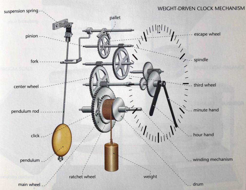
As you pointed out that Cartesian Coordinates are to a milliseconds arc. It was possible to get an accurate milliseconds arc measurement during the period the Voynich was created. To do so the creators of the Voynich Manuscript used an instrument and machine that the authors went to great lengths to hide. The answer you seek we have not published as of yet but given that it causes confusion we will let the Schrodinger’s cat out of the bag. Folio’s 57v-73v are schematic designs on a new invention of the time – the clock! They where using an Antikythera Mechanism (invented around 200 BC and is the oldest form of an analog computer) driven by a clock. With this, one could navigate anywhere in the world. How to build a clock was structured in the VM as follows:
Folio 57v: Clock Escapement Gear Train Setup
Folio 58r-58v: Explanation of How Clocks Work
Opening Line: “The hole in the crown (clock escapement mounts onto the escapement wheel) frees going by night. To work, mark and remove into it. The observation swinging motion outside forces the hours to regulate.”
Folio 65r-65v: “eloch soh oioh” You are going the Grid: Latitude and Departures Grid Schematic Design
Folio 66r-66v: How to Operate a Clock Escapement and gears: “eluio som ula atyr uish” separation measurement crutch above.
Folio 67r-73v: Set up of Clock Background Plate: Every time you change 30 degrees latitude you have to change the background plate of the clock which alters the time calculations.